
As of 11:20 AM today, November 11, the Philippine Atmospheric, Geophysical, and Astronomical Services Administration (PAGASA) raised Metro Manila and other Luzon provinces including Calabarzon, and Bicol Region under Tropical Cyclone Wind Signal (TCWS) No. 3, as Ulysses (Vamco) intensified from a severe tropical storm into a typhoon earlier at 8am.
In a press briefing past 11 AM today, PAGASA said Ulysses now has maximum sustained winds of 125 kilometers per hour (km/h) from the previous 110 km/h and gustiness of up to 155 km/h from the previous 135 km/h.
PAGASA also reported that Ulysses may reach its peak intensity of 130 to 155 km/h before landfall.
PAGASA also warned that typhoon Ulysses may trigger a storm surge “as high as three meters over the coastal areas of Quezon” including Polillo Islands, Camarines Norte, Catanduanes, and the northern and eastern coastal areas of Camarines Sur.
Meanwhile, a storm surge as high as two meters may occur over the coastal areas of Metro Manila, La Union, Pangasinan, Isabela, Zambales, Aurora, Bataan, Pampanga, Bulacan, Cavite, Batangas, northern portions of Mindoro Provinces including Lubang Island, Marinduque, Romblon, Masbate including Ticao and Burias Islands, Albay, and Sorsogon, and the remaining coastal areas of Camarines Sur.
“These storm surges, which may be accompanied by swells and/or breaking waves near the coast, can cause life-threatening and damaging coastal inundation,” PAGASA said.
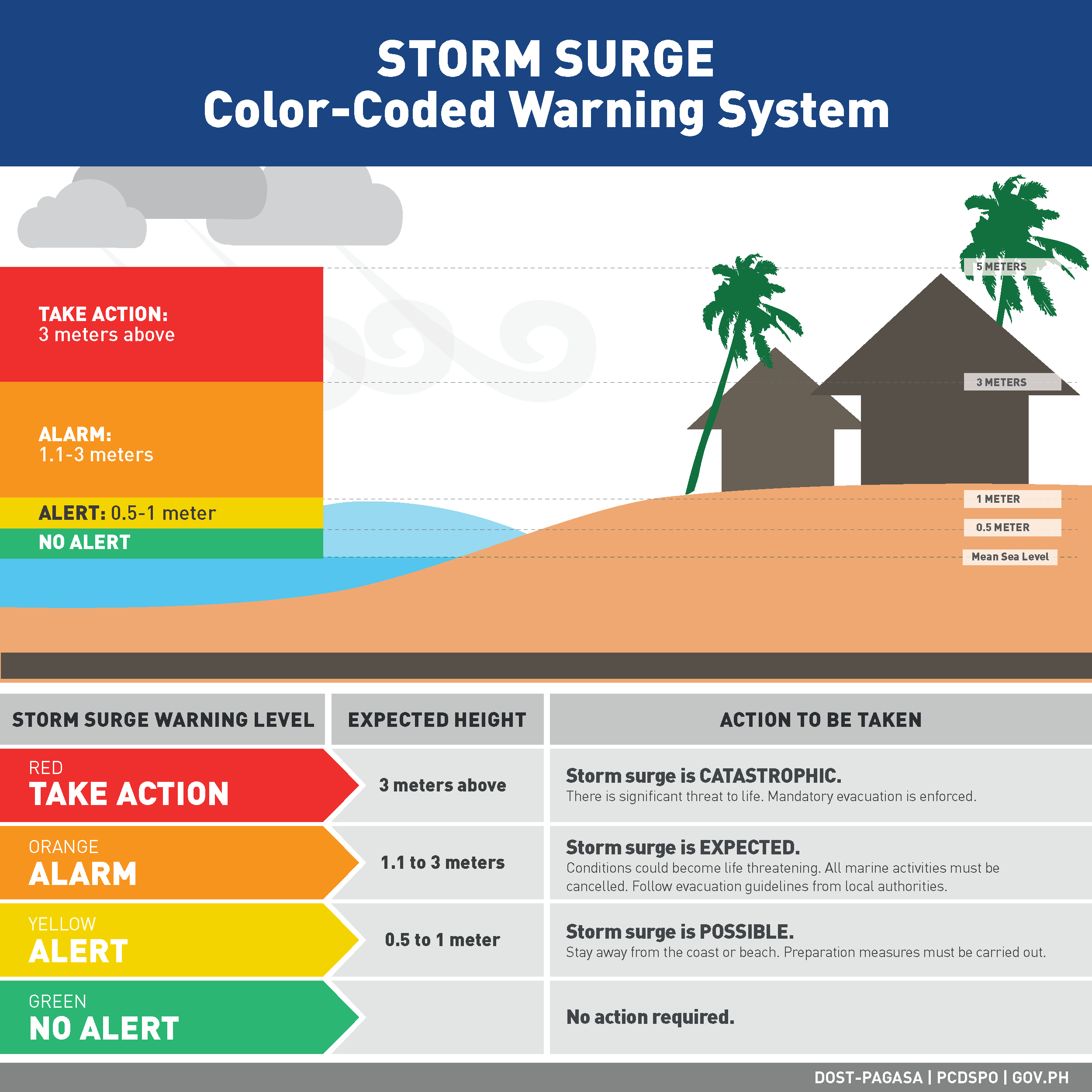
What you need to know about Storm Surge
Storm surge is the abnormal increase of water level in seashores triggered by wind associated with a storm nears coastal lines. Storm surge occurs when storms produce strong winds that push the water into shore, which can lead to flooding. This makes storm surges very dangerous for coastal areas.
How to prepare for a storm surge
Always be updated about the storm. Storm surge warnings can be found in the PAGASA Severe Weather Bulletin.
PAGASA strictly recommend for all residents living in low areas of the seashore to move to more elevated areas and keep in mind all reminders and warnings on floods brought by the storm surge. The color-coded warnings from PAGASA are used to emphasize the severity of the impact of the storm surges.
PAGASA also reminded everyone to:
Follow weather updates from PAGASA and other assisting government agencies like Philippine Coast Guard and NDRRMC via the radio, television, or internet.
Always be prepared for the possible evacuation to a more elevated area or evacuation center even before the storm surge occurs. Always remain calm and composed. Prepare and bring clothes, food and water, first aid kit, flashlight, and battery-operated radio.
Upon evacuation, make sure to keep at least 500m distance from a flat coast if the storm will pass directly in your area which will cause storm surge in your community.
For questions and additional information, coordinate with:
NDRRMC
Website: www.ndrrmc.gov.ph
Email: ndrrmc.secretariat@yahoo.com
Tel no.: 912-0441
Philippine Coast Guard
Website: www.coastguard.gov.ph
Tel no.: 527-8481 loc 6290/6292
PAGASA
Website: www.pagasa.dost.gov.ph
Email: pilas@pagasa@dost.gov.ph
Tel no.: 434-2696
Related Reads
What's New
More Articles


